
My last newsletter highlighted the products on the National Geodetic Survey (NGS) Alpha Preliminary Products site. The alpha site provides products that individuals can use to better understand the products that will be distributed as part of the new, modernized National Spatial Reference System (NSRS).
This newsletter is going to highlight activities associated with the Transportation Research Board’s ADK70 Standing Committee on Geospatial Data Acquisition Technologies. This committee is concerned with applications of high-accuracy geospatial data acquisition technologies in support of the digital infrastructure for the design and construction of transportation facilities. Members have various backgrounds and expertise and are located in different regions of the United States.
The committee holds two meetings a year, one at the January TRB Annual Meeting held in Washington, D.C., and a summer meeting in different locations each year in late July.
This year, the meeting of the Geospatial Acquisition Technologies in Design and Construction Summer Committee was held on July 29-31, 2024, in Washington, D.C. Topics included new technologies on data collection, modeling and plan delivery. There were updates from organizations such as the National Geodetic Survey, the Federal Highway Administration, the American Association of State Highway and Transportation Officials and various state departments of transportation on technology, standards, specifications and industry needs. See the agenda below.


I first got involved with this committee in 1999, when I worked for NGS. One may ask, why would a geodesist be interested in a committee that focuses on the design and construction of transportation facilities? In my opinion, this is an important committee that addresses geospatial issues that affect all users of geospatial data, not just state Department of Transportation (DOT) surveyors and engineers.
As anyone who has been reading my GPS World Survey Scene newsletters knows, I remind everyone that “geodesy is the foundation for all geospatial products and services.” As previously stated, this committee is concerned with applications of high-accuracy geospatial data acquisition; therefore, surveyors and geodesists must be involved to address issues associated with positioning. Anyone using or acquiring geospatial data should be interested in this committee’s activities.
During AKD70 summer workshop meetings, participants talk with technical experts about the latest advancements in geospatial data acquisition technologies. I would encourage anyone interested in high-accuracy geospatial data acquisition technologies to learn more about this TRB committee, which is currently chaired by Wei Johnson, South Carolina DOT.
Digital delivery geometric consistency concerns
One session at the meeting discussed concerns with digital delivery geometric consistency. We now live in a world where everything is digital. Today, most surveying and mapping instruments collect and generate data in digital format. This paradigm has affected how surveyors, geodesists, and engineers provide their products and services. So, what is the issue with digital delivery geometric consistency?
As I previously stated, I am a geodesist, so I think in geodetic coordinates (latitude, longitude, ellipsoid and orthometric height) or cartesian coordinates (X, Y and Z).
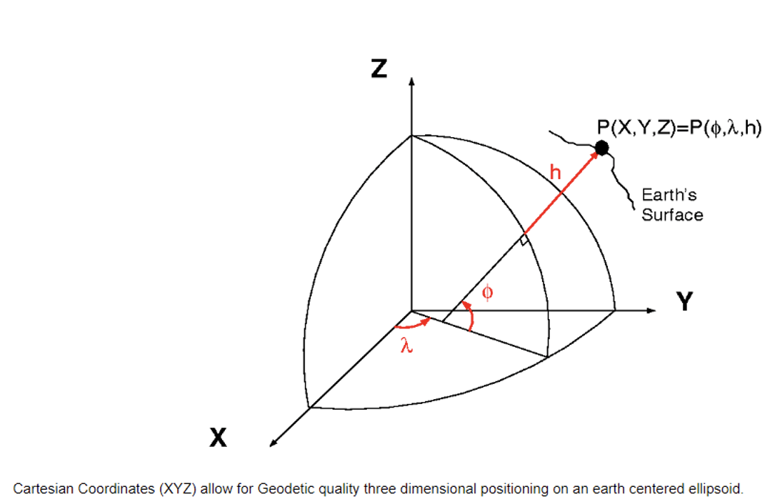
Three-Dimensional Positioning (XYZ). (Photo: NGS)
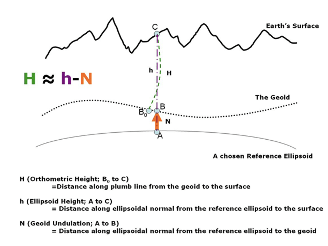
Orthometric, Ellipsoid and Geoid Heights from NOAA Technical Memorandum NOS NGS 59. (Photo: NGS)
Looking at the diagram in the above image, I would like to highlight that the orthometric height is measured from the geoid along a curved line. The curved line is based on an infinite number of geopotential level surfaces that exist between the geoid, which is a geopotential surface, and the mark located on Earth’s surface. This is why gravity plays a part in determining the orthometric height of a mark.
This means that leveling height differences are not the same as ellipsoid height differences. To compute a GNSS-derived orthometric height, a geoid height is subtracted from the GNSS-derived ellipsoid height. This is only an approximation because of how the two heights are measured but, at this moment, it is accurate enough for surveying and mapping applications.
What about computing an ellipsoid height from an orthometric height? The ellipsoid height can be computed using the equation h = H + N (ellipsoid height = orthometric height + geoid height). Once you have an ellipsoid height, you can compute the X, Y, and Z coordinates of the mark. Orthometric heights derived from leveling data are one-dimensional (orthometric height only), whereas GNSS-derived coordinates are three-dimensional (XYZ or latitude, longitude, ellipsoid height). Therefore, to compute a cartesian coordinate (XYZ), from a leveling-derived height users must generate a latitude and longitude of the mark. It is important to use the appropriate geoid height and to record that information in a metadata file.
NGS has developed web-based applications to convert coordinates between different coordinate systems and transform between different reference frames and/or datums. See the box titled “NGS NCAT Web Tool.” I described the NCAT web tool in my October 2019 and September 2023 GPS World newsletters.
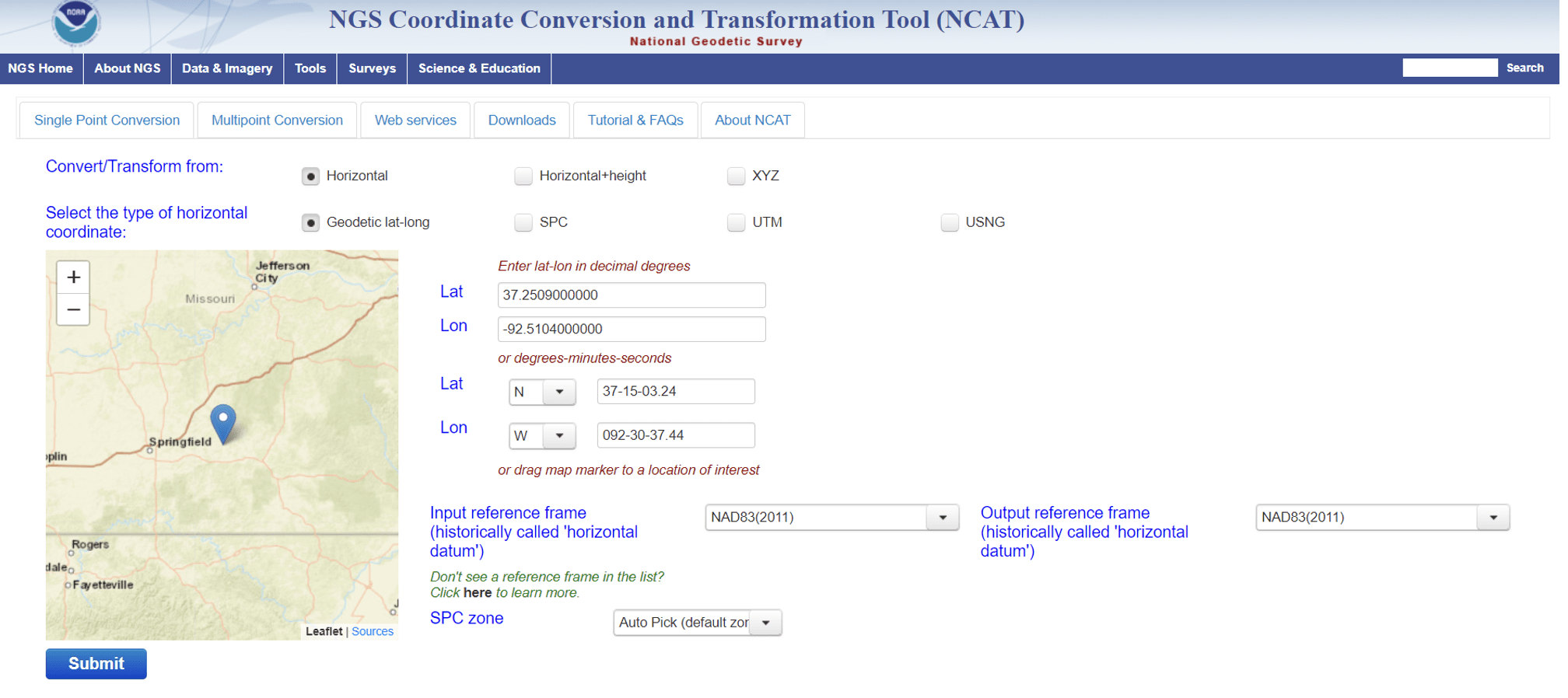
NGS NCAT web tool. (Photo: NGS)
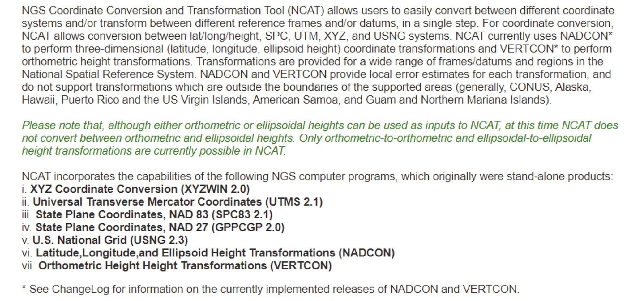
Photo: NGS
So, from a geodesist’s point of view, there is no issue with digital delivery geometric consistency if the appropriate tools are correctly used to convert coordinates between different coordinate systems and transform them between different reference frames and/or datums. That said, unique coordinate systems may be used by engineers to create 2D and 3D as-built drawings, such as blueprints and models. This should not be a problem for developing a transformation model if the appropriate information is available.
The AutoCAD Map 3D website states that users can combine data from maps using different coordinate systems (see the box titled “Excerpt from AutoCAD Map 3D Site”). The site states that “AutoCAD Map 3D toolset automatically converts them to the coordinate system of the current drawing.” This is an indication that CAD routines are working on handling different coordinate systems.
That said, users should make sure that the conversions and transformations are using the correct formulas and parameters. For example, I would like to know what defines the Latitude-Longitude 84 coordinate system that is highlighted in the box. I am not suggesting that anything is incorrect in the definition of the coordinate system. I am just saying that I do not know what the statement means; I would need more information before I can use the data.
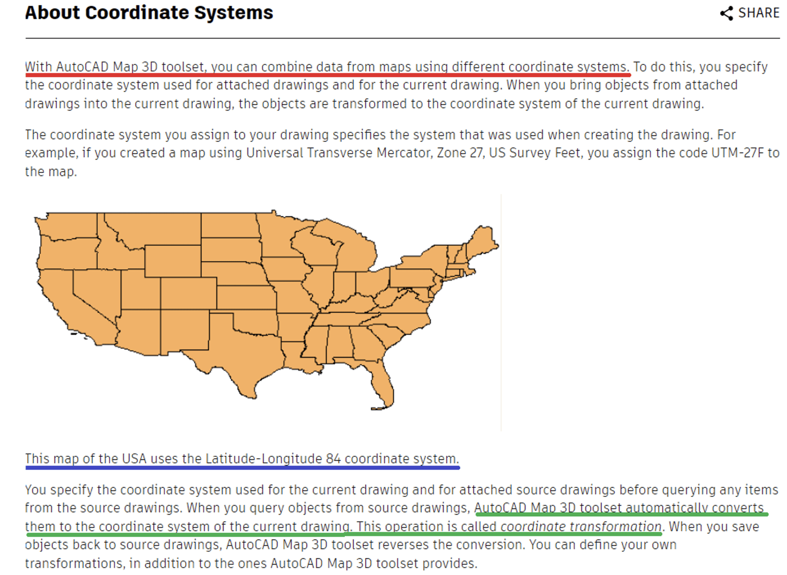
Excerpt from AutoCAD Map 3D 2025 site.
That said, ESRI and Autodesk, two industry leaders, have created a partnership to integrate GIS and Building Information Models (BIM), which seeks to create an integrated and collaborative workflow that connects data sources. ESRI denotes this as ArcGIS GeoBIM.
Representatives from ESRI and Autodesk participated in the meeting. During the meeting, Linda Foster, ESRI and President-Elect of the National Society of Professional Surveyors (NSPS), gave a presentation that included a discussion of the ArcGIS GeoBIM web-based tool. Linda highlighted how geodesy and surveying provide the foundation for Digital Twin products. Her presentation included a diagram that I have recreated below.
Notice that geodesy is at the base and digital twin is at the top of the inverted triangle. See the box titled “Geodesy Provides the Foundation for all Geospatial Products and Services.” The diagram is like the one I highlighted in my February 2022 GPS World Newsletter to emphasize the geodesy crisis. Both diagrams emphasize the importance of geodesy and surveying in creating geospatial products and services. It is encouraging to see that ESRI and Autodesk are working together to understand the needs of both communities. This will lead to the development of an improved system.

Image: Dave Zilkoski — based on Linda Foster’s presentation at the TRB AKD70 summer meeting on July 30, 2024.
From a geodesist’s viewpoint, there does not seem to be a problem with digital delivery geometric consistency. Of course, I know that it is not as simple as I am making it. I realize that the “devil is in the details,” which means that something that appears to be simple will identify issues that will have to be dealt with during development and implementation. During the meeting, it was announced that the TRB AKD70 Committee is developing a webinar titled “Resolving ambiguities between 3D virtual models and the real world” to make people aware of the issues.
Proposed Webinar
Proposed title: “Resolving ambiguities between 3D virtual models and the real world”
Proposed description: The transportation industry is rapidly moving towards achieving digital product delivery and digital as-built objectives in the Civil Infrastructure sector. They are doing this by adopting a 100% end-to-end digital, asset-centric, interoperable data flow. However, the current methodologies being discussed use outdated concepts that rely on 2D/1D plans and profile/cross-section sheets as part of physical construction reality. These methodologies are not in line with current construction objectives, which require the use of Open BIM and Digital Twin concepts. Therefore, it’s crucial to address the current geospatial and geodesic ambiguity between the real world and BIM (virtual 3D models) to ensure a clear understanding of the proposed solution and its efficient implementation. This is especially important considering the industry’s reliance on Global Navigation Satellite System (GNSS) measurement methodologies. There is an imperative need to resolve this geospatial and geodesic ambiguity by adopting sound geodetic methodologies. The webinar will present the basic tenets of geodetic engineering from three points of view: the Department of Transportation (DOT) perspective, the digital product delivery perspective and the Survey/Geodesy perspective.
Proposed purpose: To raise awareness among the DOT community, which is intent on achieving the 100% digital end-to-end asset-centric interoperable flow objectives, of the need to resolve the ambiguities between virtual 3D models and the real world.
I always learn something new at these meetings and continue to build new relationships expanding my professional network. These meetings are open to anyone, so I would encourage everyone to learn more about the TRB ADK70 Standing Committee on Geospatial Data Acquisition Technologies. Please contact Wei Johnson for more information about getting involved with the committee.
<p>The post TRB ADK70 Standing Committee on Geospatial Data Acquisition Technologies summer meeting first appeared on GPS World.</p>

