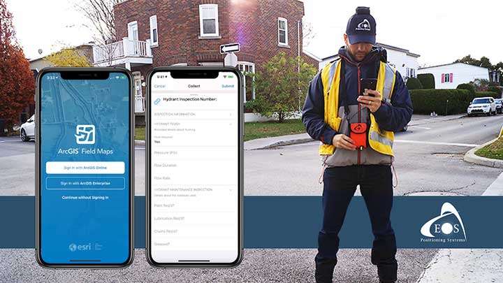
A new Esri mobile app, ArcGIS Field Maps, will be released in its first beta in July, with the final version expected to be released in September.
According to Esri, Field Maps will combine the following capabilities into a single app:
- Simple map viewing and markup
- High-accuracy field data collection and inspection
- Battery-optimized location tracking
- Work planning and task management
- Turn-by-turn navigation
Field Maps also will include a new web app, integrated with ArcGIS, that can be used to configure and deploy maps optimized for your mobile workforce needs, create and assign tasks to mobile workers, and create and share views of worker locations.
Arrow support included
The inaugural beta includes support for Arrow GNSS receivers’ high-accuracy locations, elevations and metadata, according to Eos Positioning.
ArcGIS Field Maps will provide the combined functionality of five Esri mobile apps: ArcGIS Collector, ArcGIS Explorer, ArcGIS Tracker, ArcGIS Workforce and ArcGIS Navigator.
In the first beta version, users will be able to perform markups, work with read-only maps, and work with MMPKs, including high-accuracy GPS locations and metadata from Arrow GNSS receivers.
Customers who have been wanting to take advantage of high-accuracy GNSS data in apps such as Explorer and Tracker will now be able to with the beta release. Customers who would like to have field crews able to access read-only maps with high-accuracy, for instance (such as during utility locates), this is now a possibility. In addition, crews can take advantage of high-accuracy GPS tracks while tracking.
ArcGIS Field Maps will also support the two formerly Collector-exclusive Eos solutions Eos Locate and Eos Laser Mapping.
Eos Locate. This high-accuracy underground mapping solution will be available in ArcGIS Field Maps right away in the first beta release. A single fieldworker will be able to perform real-time, high-accuracy mapping of underground assets using the same workflow he or she had previously used with Collector and Arrow GNSS.
Eos Laser Mapping. Similarly, laser offsets with Arrow GNSS receivers and LTI laser rangefinders will be available in the first beta of ArcGIS Field Maps. Learn more about laser offsets, including the three workflows for using them, here:
“We are incredibly excited for the new opportunities ArcGIS Field Maps brings to expand our partnership with Esri,” Eos CTO Jean-Yves Lauture said. “Now our joint customers will be able to use the Arrow GNSS receivers with Field Maps to access high-accuracy location when simply viewing and marking up maps and when logging location tracks.”
Eos Positioning told its customers, “We encourage all Eos customers currently using Collector, Tracker and/or Explorer to join the beta. Meanwhile, Collector, Tracker and Explorer are planned to continue working as usual, according to the roadmap Esri has outlined.”


