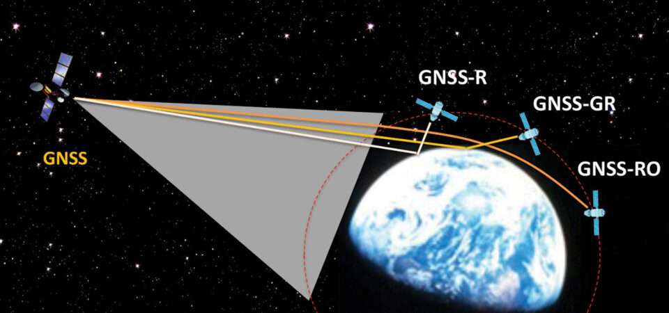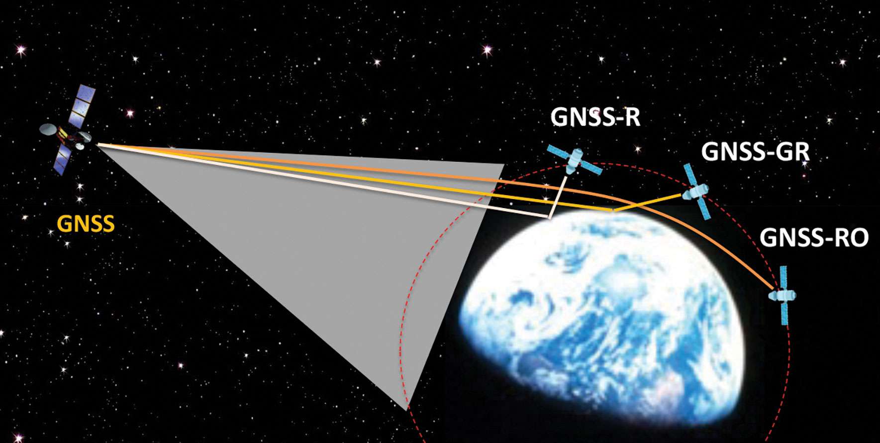
Figure 1: Scientific observations with GNSS radio occultation (GNSS-RO), GNSS grazing-angle reflectometry (GNSS-GR) and GNSS reflectometry (GNSS-R) techniques from low-Earth orbit (LEO). (Figure provided by the author)
Global navigation satellite systems (GNSS) for peaceful uses are facing a hard reality due to increasing regional conflicts in recent years. As a dual-use technology, GNSS for civil, commercial and scientific applications is vulnerable to both denied/degraded service and flex power operation from GNSS satellites and to jamming from the ground.
One of the vulnerable scientific applications is the use of GNSS receivers on low-Earth orbit (LEO) satellites that utilize the civil navigation signals for Earth observation. These remote sensing techniques, such as GNSS radio occultation (GNSS-RO), GNSS grazing-angle reflectometry (GNSS-GR) and GNSS reflectometry (GNSS-R) (see figure 1), are designed to observe weak GNSS signals either bounced off from Earth’s surface or refracted by the atmosphere. Thus, GNSS flex power operation and intentional radio frequency interference (RFI) can severely degrade the quality of the scientific data or even prevent Earth observation.
One example of such impacts is a dramatic decrease of GNSS-RO observations over Europe and the Middle East during 2023. Monthly statistics from Spire show the region without GPS-RO measurements grew substantially from the localized Ukraine-Russia conflict zone in January to a much wider area in Eastern Europe and the Middle East in December 2023 (see figure 2).
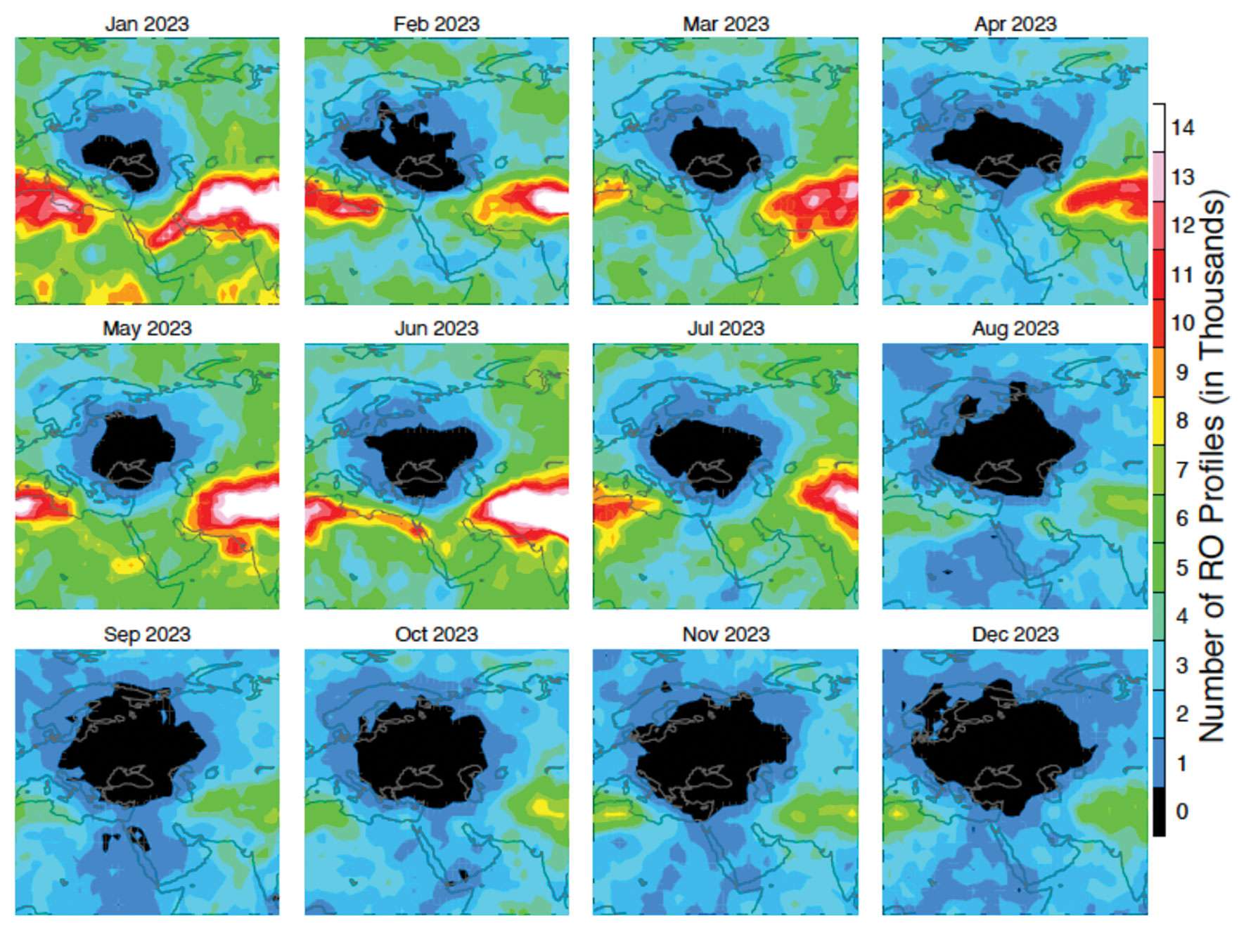
Figure 2: Number density distribution of monthly GNSS-RO measurements from the GPS tracking by the Spire constellation over Europe and the Middle East in 2023. The black area indicates no data. (Figure provided by the author)
This vast data void in the science observation is likely a result of the intensified electronic warfare used in Ukraine-Russia and the nearby conflict regions. The Spire RO receivers are configured to track the civil signals from GPS, GLONASS and Galileo. To increase signal protection against jamming in a conflict zone, GNSS service providers often use flex power operation. However, flex power operations can cause poor quality tracking with the RO receiver due to weaker signal power. Unlike a precise orbit determination (POD) antenna, the GNSS-RO antennas typically have a high gain to improve the detection of weak GNSS signals at limb and occulted views. However, if the transmitter power of civil signals drops below a quality-control (QC) threshold, the data are flagged as bad. This results in a poor coverage of Spire GNSS-RO in the conflict zones.
Lost or degraded GNSS-RO, GNSS-R and GNSS-GR observations are unfortunate, as these all-weather sensing, long-term stability, and high-accuracy measurements are becoming increasingly important in scientific research. GNSS-RO is a remote sensing technique that uses the GNSS-LEO link to profile Earth’s atmosphere and ionosphere with high vertical resolution. Since the first GNSS-RO six-satellite constellation, known as Constellation Observing System for Meteorology, Ionosphere and Climate-1 (COSMIC-1), these high-quality RO profiles have become a key data source for weather forecasting, climate monitoring, model evaluation, and space weather research. The current backbone of GNSS-RO observations comes from the COSMIIC-2 and Spire constellations, which have been producing more than 20,000 profiles per day since 2020. GNSS-R is a bi-static radar technique that uses the GNSS signals reflected by the surface for altimetry, ocean surface wind speed, wave height sea ice, soil moisture, and inundation measurements. At a view angle between GNSS-RO and GNSS-R, GNSS-GR can provide complementary measurements for sea ice and atmospheric column water vapor. Because of low-cost LEO SmallSat/CubeSat constellations with the GNSS receivers, geoscience studies have benefited greatly from the sampling density and coverage of these new data.
Civilization and science have been diverted by wars before. Despite the increased dependence on GNSS in recent years, their vulnerability to jamming and flex power operation poses a great challenge for scientific observations that need uniform global coverage.
The post Research Report: A Black Hole in Earth science first appeared on GPS World.
